Imagine trying to cross six lanes of traffic just to buy a carton of eggs, weaving a bike between vehicles zipping past at 50 miles an hour or standing at a bus stop watching the only bus of the hour drive off. For decades, these were the everyday realities many Americans across the country dealt with. While such experiences should not be considered normal, they highlight the notion that American cities were built for vehicles rather than people.
Even for many students at Plant High School, a car has been the primary mode of transportation. “I take the car to school,” Oliver Habiyakare (12), said. “Getting there is safe but a little hectic because of traffic, so we have to leave 30 minutes earlier than school starts even though I live 10-15 minutes away.”
This issue is not unique to Habiyakare or Plant students. Since the 1950s, cities across the United States have seen a growing dependence on automobiles. When cars were just introduced, Henry Ford’s assembly line made them affordable for middle-class Americans. Additionally, the federal government had just started investing in the national interstate system. While these advancements may have been celebrated at the time, the result was highways cutting through cities, dividing neighborhoods and communities, and creating barriers to walkable spaces.
But a shift has finally started to take place across American cities.
The Step Away From “Car-Centricness”
In recent years, larger cities across the nation have taken steps to reverse the car dependency trend. For instance, New York is investing in its subway system, aiming to connect underserved communities. According to New York’s Metropolitan Transportation Authority (MTA), one of the key projects includes a subway link to connect Brooklyn and Queens set to be completed by 2029, cutting the travel time between the two boroughs in half. Similarly, Chicago’s Chicago Transit Authority (CTA) announced plans to extend the city’s Red Line by 5.5 miles, adding four fully accessible stations with multimodal connections—including bus, pedestrian and bike—at each.
These strides are not just limited to major metropolitan areas. Smaller cities and towns are also making improvements in public transportation. California’s High-Speed Rail (CHSR) system leads by example, aiming to connect towns and cities—including Bakersfield, Fresno, Los Angeles and San Francisco—across the state by rail.
Additionally, Colorado’s Bustang System has implemented intercity bus services between towns like Denver, Fort Collins, Greeley and Pueblo, providing affordable and eco-friendly transportation. In 2025, the company saw a total of 351,000 riders, marking a 240% increase from its initial year, 2015.
Michigan is also making notable progress in connecting smaller towns to larger hubs, specifically through its Great Lakes Corridor Project. This initiative aims at improving rail and bus service between Detroit, Flint and other towns. Specifically, its major goal is to extend its Amtrak rail service and add four new bus lines, according to Michigan Department of Transportation (MDOT). The department also stated its aims to increase reliability and frequency in its public transit system, encouraging greater use for everyday needs. Developments such as these signal a growing commitment to less car dependency across the United States.
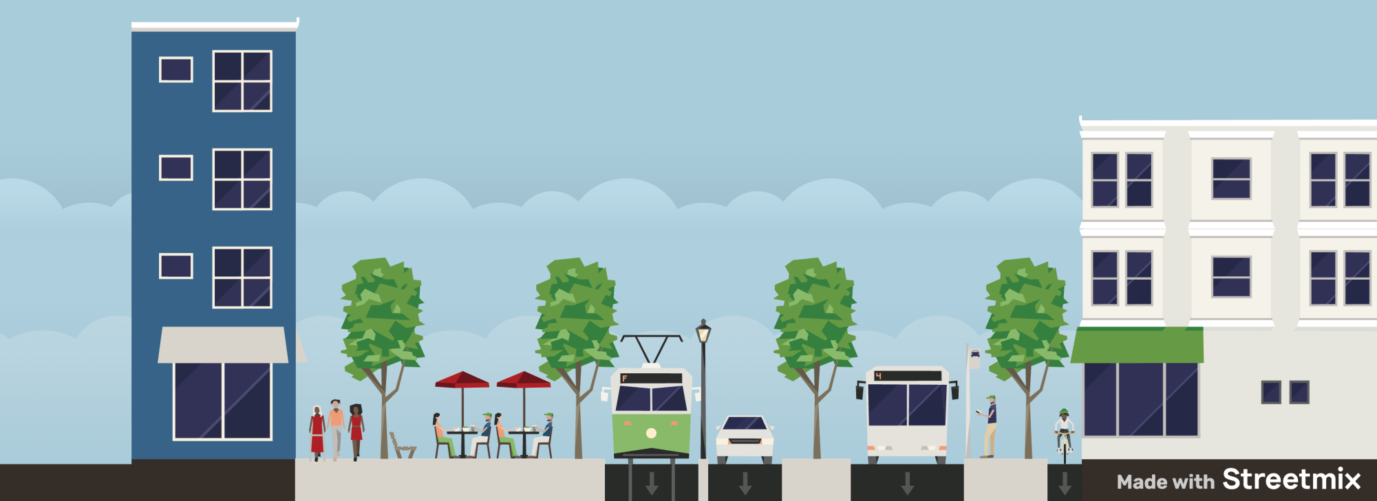
On Two Wheels: How Bikes are Reshaping American Urbanism
Bikes are becoming a key solution for creating sustainable and reliable infrastructure. The addition of designated bike lanes and bike-share programs highlights the integration of biking into everyday life. Biking is evolving into a primary mode of transport, playing a role in efficient and healthy urban environments.
In 2024, the League of American Bicyclists conducted a nationwide study to identify the country’s “bike-friendliest” states. The state of Washington outperformed the rest, ranking first in bike policies and infrastructure, fourth in funding and seventh in safety. By December 2024, the state had passed a landmark $1 billion initiative to construct 900 miles of protected U.S. Bicycle Routes, stretching from major cities like Seattle and Tacoma to smaller towns such as Pullman and Walla Walla. Seattle alone saw a record-breaking six million bike lane users in 2024, thanks in part to the addition of 10 miles of new bike lanes.
Additionally, Washington allocated $216 million to biking education, ensuring that residents are well-informed about proper bike lane use. In counties like King and Pierce—Washington’s two most populous—laws now mandate that cyclists wear helmets, further promoting safety.
These combined efforts aim to make biking safer and more accessible to everyone, serving as a central part of the state’s transportation and health strategy. Washington’s success in building bike-friendly infrastructure serves as an example of how investments can lead to better health outcomes—lessons other American states can benefit from.
Individual cities in the United States are also taking significant steps to improve bike infrastructure, with Portland, OR emerging as a top example. In 2010, Portland became the first U.S. city to make protected bike lanes the default mode of construction, aiming to enhance safety, mobility and accessibility for cyclists of all ages. In the same year, the city also introduced the Portland Bicycle Plan for 2030, a bold initiative with the goal of adding 500 miles of bike lanes by 2030. As of 2024, Portland has built 385 miles of bike lanes. The city has also prioritized 100 miles of neighborhood greenways, low traffic residential streets designed to provide safer and scenic routes for cyclists.
In 2016, the city launched “Biketown,” a bikeshare system operated by the Portland Bureau of Transportation and sponsored by Lyft. This system allows users to rent bikes by scanning QR codes, providing a convenient method for commuting, running errands and exploring the city’s public spaces.
The Push for Multi-Modal Urban Spaces
For years, walking was an afterthought in American urban design. People were forced to use cars because city designers treated residential neighborhoods like highways. In theory, a street is meant for humans and everyday activities—walking, biking and simply living—flanked by buildings and design cues on both sides to encourage slower speeds. On the other hand, a road is meant to connect two or more cities together, often characterized by wider lanes and higher speeds, such as highways and freeways. But in many American cities, streets and roads were often combined into what is known as a stroad, a hybrid designed for high-speed traffic and local access to businesses—yet failing at both. The results were dangerous corridors where pedestrians and bicyclists needed to navigate through multi-lane traffic to reach their destinations.
But many cities in the United States are taking initiatives to convert their stroads into pedestrianized areas. Lancaster, California, is a notable example. Prior to 2009, the city’s main Boulevard, Lancaster Blvd, was a five-lane high-speed road with businesses on both sides. But in 2010, the city invested $11.5 million into the road’s nine blocks, revitalizing it into a two-lane street meant for people. While vehicles are still allowed, the redesign has added obstacles to naturally reduce speeds. A wide buffer now runs through the center of the two lanes, lined with trees and greenery to offer shade and a sense of belonging. Additionally, the city made the sidewalks wider, allowing for more room to walk and gather. The results of these changes are drastic. According to cnu.org, pedestrian-involved collisions dropped by 78%, while traffic collisions dropped by 38%.
While Lancaster Blvd’s transformation shows how a stroad can be turned into a street, Carmel, Indiana demonstrates how an entire community can prioritize people. In 1995, the city’s mayor, James Brainard, visited the United Kingdom and was drawn by the design of walkable towns that balanced vehicle accessibility with pedestrian comfort. Specifically, he was inspired by the use of roundabouts, and upon returning to Carmel, turned every traditional intersection into one. Today, with over 150 in use, Carmel is the roundabout capital of the United States. And according to the City of Carmel, vehicle collisions have reduced by 80% and overall accidents by 40%. Carmel has also utilized a multi-use path network to connect people to destinations without having to rely on vehicles. The city’s 14-foot wide Monon Greenway runs through the core of the city, linking residential areas to schools, parks and other public areas. This design allows people to walk or bike safely, while also encouraging community engagement and support for local businesses, reinforcing Carmel’s commitment to “human-centric” infrastructure.
While the United States still has ways to go in terms of urbanism, many regions around the country are starting to emphasize people over vehicles. The shift toward walkable streets, accessible and improved public transit, and safer biking infrastructure shows a growing dedication to healthier, more connected communities.